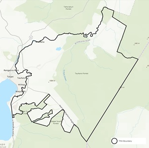
East Taupō TB response area
The Taupō TMA is part of the East Taupō TB response area. Use the link below to find out more about the TB testing plan and pest control operations in the response area.
The Taupō TMA is part of the East Taupō TB response area. Use the link below to find out more about the TB testing plan and pest control operations in the response area.
As part of our TBfree programme we deliver our pest control operations through a framework of TB management areas (TMAs). TMAs are areas with known TB infection in livestock or wildlife. Each TMA has a specific TB control plan designed to eradicate TB as effectively as possible.
 The Taupō TMA
The Taupō TMA is directly west of the Taupō urban township. The northern boundary of the TMA is the Waikato River from State Highway 1 to the Taupō township, around the eastern edge of the township, and then south to the edge of Lake Taupō. The eastern boundary of the TMA runs from the lake’s edge, near Waitahanui, to the Kaingaroa Forest, and then northward through parts of the forest, back to the Waikato River.
The habitat includes forestry, farmland and a mountainous area.
The Taupō TMA has a long history of TB infection in cattle herds and local wildlife. We found 9 infected cattle herds between 1990 and 2004.
Control in this TMA occurred between 2007 and 2016. Most recently we completed aerial and ground control in 2013/2014, 2014/2015 and 2015/2016.
After recently finding 2 infected cattle herds in this TMA, we are restarting ground control and wildlife surveillance.
As of April 2025, there are 1 infected herd in the Taupō TMA.
The Taupō TMA sits across the Taupō annual and North Taupō biennial Special Testing Areas. In these areas, cattle over 12 months and deer over 15 months of age are tested annually, or every 2 years, respectively.
We plan our pest control operations up to 3 years in advance. The current year runs from July 2024 to June 2025.
Dates and control methods for pest control operations in Taupō are provisional and subject to change. If you’re affected by any upcoming operations, our pest control contractors will contact you before work begins. They will:
| Type of control | When | Coverage | Where |
|---|---|---|---|
| Ground control | 2024/2025 | 22,183ha | East Taupo Sector 1A Farmland, East Taupo Sector 1A Forest, East Taupo Sector 1B, East Taupo Sector 3A (Orakonui), East Taupo Sector 3A (Pueto Stream), East Taupo Sector 3A (Rotokawa), East Taupo Sector 3A (Waipari Stream) |
| Pig survey | 2024/2025 | 41,214ha | East Taupo (Tauhara) |
On the map, the proposed areas for:
Interactive map showing Taupō TB management area boundaries, Vector Control Zone, and proposed control areas.
EPRO Limited manages eradication activities (except those in Sector 3A) in the Taupō TMA. Contact them directly if you have feedback or questions about upcoming operations. For feedback or questions on Sector 3A activities, contact OSPRI.
Phone: 07 378 4852/0800 275 3776
Email: control@epro.co.nz
OSPRI Palmerston North office
PO Box 9078
Terrace End
Palmerston North 4441
Phone: 06 353 2710
Email: vector.sni@ospri.co.nz